 ?
?
SARANGANI
Report, photos & video?by Ben Jason Tesiorna
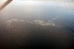
Oil slick is seen Thursday, August 11, in the vicinity where MV Bulk Carrier 1 sank Tuesday night after colliding with foreign cargo vessel HS Puccini off Matil Pt. in Lumatil, Maasim, Sarangani.
The area is within the Sarangani Bay Protected Seascape and falls under NIPAS (National Integrated Protected Area System) through Presidential Proclamation Number 756 promulgated in 1996.
Have You Been Affected? Click Here
Photo Credit: Ben Jason Tesiorna
The Philippine Coast Guard (PCG) also reported Thursday a "very thin layer of oil on the surface." The PCG was determining the stretch area while spraying dispersant. Assessment continues while the entire area is covered.
The slick's closest point to shoreline is 4.2 nautical miles.
On the ground, Vice Governor Steve Chiongbian Solon was preparing contingency measures with barangay and municipal officials and volunteers in case the slick hits the shoreline.
PCG personnel were in the area with spill booms and oil spill containment and recovery materials to observe, monitor and combat the spillage.
Want To Contribute Stories/Features? Click Here
275
Posted at: 05:50 | Add Comment  |
|  |
|  del.icio.us